A Covered Bridges Route in Northern Vermont
from an October 2005 posting in the foliage forum by PWT.
A good covered bridge route in northern Vermont is this: Route 109 between routes 108 in Jeffersonville and route 118 in Belvedere has 5 covered bridges on route 109. The first is in Waterville Village on the street across from the "church" with the clock. The second is right next to the road on the right side. the third is about 7/10th of a mile north of that bridge on the Codding Hollow Road. Continue on route 109 north and look for the Waterville elementary school on the right. About a mile past the school you come to a small community.
As you go across the bridge look to the left for the Back Road. Take that road to the next covered bridge. Drive through the bridge and continue the Back Road to the last covered bridge. Now, you can continue the Back Road to the end on route 109 and turn left. Or you can drive through the covered bridge back to route 109 and turn left. Finish route 109 north to route 118 and turn right. There is a pond about a mile from the intersection. There may be a photo opportunity there.
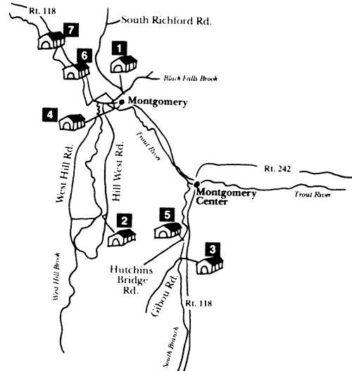
Continuing route 118 this way will take you to route 100 in Eden. Turning around and going back past route 109 will take you to Montgomery and its covered bridges. There is a covered bridge on the South Brook Road to Hutchins Road. The South Brook Road is about 7 miles north of route 109 and on the left side. There is a sign that says Godfrey's Sugarhouse about 500 feet before the road. Drive route 118 through Montgomery Center to Montgomery.
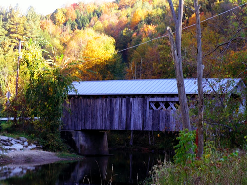
Montgomery's Comstock Covered Bridge - to see all of Montgomery's covered bridges, go here!
As you come into the village look for the village green on the right and you will see the next bridge. There is a bright red maple tree beside it. Go back to route 118 and turn right. Drive about 300 feet and look for the Comstock Road on the left side. Drive through the covered bridge and onto route 118 and turn left.
Now, the next covered bridge is tricky to get to and is "way out there". If you don't want to do a long drive on a dirt road or if it's raining you may want to skip this one and continue route 118 to the last 2 covered bridges. They are next to the road and on the left side. If you are feeling frisky, here goes. After you turn left off the Comstock Road you will see a road on the left called the Hill West Road. Drive past this road, over the bridge and turn left onto the West Hill Road. You are now leaving civilization as we know it. Drive up this road until you come to a 4 way intersection with the Enosburg Mountain Road on the right and the Creamery Bridge Road on the Left. Turn left onto the Creamery Bridge Road. Look for a parking area on the left and park there and walk the last 200 feet to the bridge.
All of the covered bridges in Montgomery were built by the Jewett Brothers. Their mill was just down stream. Go back to the intersection of West Hill road. Decision time. If you have had enough, turn right to get back to route 118 and civilization. If it's a nice day and you like the ride so far, turn left and continue up the West Hill Road. Look for a road on the left just past the cemetery and turn left onto that road. Drive it to the end at the Hill West Road (yes, that one) and turn left to get back to route 118. Good views on this ride and usually good colors. At route 118 turn left for the last 2 covered bridges.
